Skyports Drones Optimise HOCHTIEF Bridge Construction
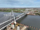
Skyports Drone Services has partnered with HOCHTIEF to provide automated Beyond Visual Line of Sight (BVLOS) drone-in-a-box aerial surveying at the Rheinbrücke Leverkusen bridge construction site on the River Rhine, north of Cologne, Germany.
Automated drone surveying can improve progress tracking, survey accuracy and project control on a major infrastructure jobs.
It also directly addresses construction pain points: keeping large projects on schedule, reducing manual site visits and spotting problems early.

Remote operations and operational efficiency
In an innovative addition to the deployment, Skyports is overseeing its drone missions from its Remote Operation Centre (ROC) in Madrid, Spain, negating the need for on-site pilots and providing significant flexibility and efficiencies.
Alex Brown, CEO, Skyports Drone Services, says: “Large infrastructure projects are incredibly intricate and complex, with construction companies under pressure to deliver on time and on budget.
"With automated “drone-in-a-box” surveys like this we’re providing alternate perspectives and deep level data insights that can improve resource planning and catch any potential issues early, helping keep projects on track.
“Piloting the drone remotely also means we are creating operational efficiencies, improving cost and data outputs for our customers.”
Bridging the data gap with automation
Back in 2021, HOCHTIEF was awarded the contract by Autobahn GmbH to complete the Rhine Bridge on the A1 in Leverkusen. Working with partners SEH Engineering, Eiffage Métal, Iemants and Max Bögl, the company has been tasked with completing a section of the roughly one-kilometre-long bridge by the end of 2023.
Skyports has installed a fixed drone-in-a-box system at the site, enabling weekly automated BVLOS surveys that give HOCHTIEF a clearer view of construction progress.
Until now, progress tracking had relied largely on manual, subjective checks. While some drone surveys were used, they were limited, infrequent and required on-site personnel. The new setup automates the process, removing the need for on-site pilots or access.

Deep insights for complex infrastructure
The drone data is processed by DroneDeploy to produce 2D and 3D survey outputs for progress reports. The weekly 3D model helps HOCHTIEF monitor construction, identify issues early and reduce the risk of delays or cost overruns.
Klaus Grüttner, Executive Vice President Europe, HOCHTIEF Infrastructure, adds: “By partnering with Skyports, we have a leading innovator in drone technology at our side to drive our complex construction projects.
This cooperation enables us to monitor the construction progress seamlessly and cost-efficiently and to provide targeted support in billing, especially in earthworks. In addition, we benefit from precise surveying data that supports a continuous target/actual comparison and the optimisation of our construction processes.”
The bridge is due for completion in 2028 and involves major earthworks, demolition of the existing bridge and new works on both banks.
Company portals


Executives
Alex Brown
CEO, Skyports Drone Services